



Updated at 11:30 a.m. on Sunday, May 18
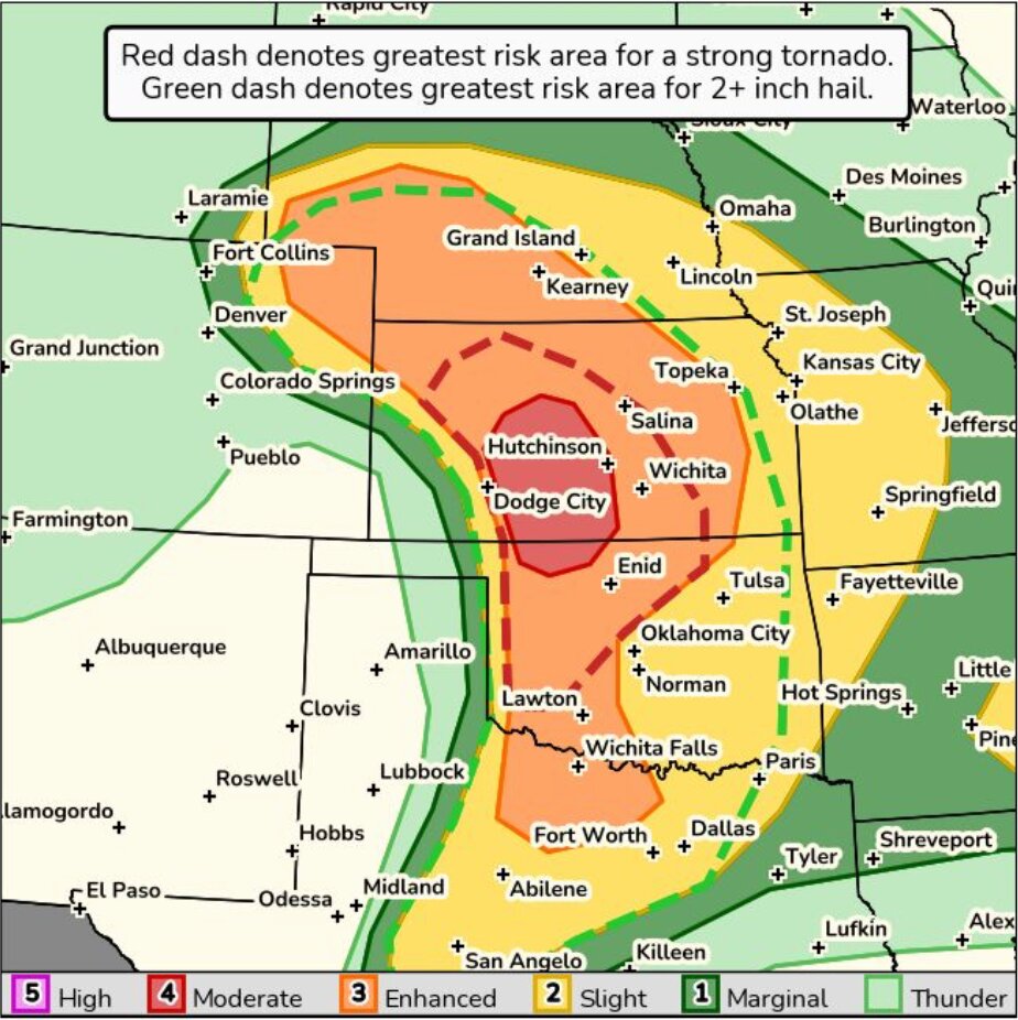
An enhanced risk for severe weather has spread across a large portion of the Great Plains for Sunday afternoon.
While the most significant concerns remain south of the north central Kansas area, National Weather Service (NWS) forecasters predict severe hail and wind concerns for northern Kansas and a large portion of Nebraska.
The National Oceanic and Atmospheric Administration/NWS Storm Prediction Center (NOAA/NWS SPC) released a moderate risk for southern Kansas, including cities like Hutchinson and Dodge City.
According to NWS forecasters, severe storms are expected to develop by mid-afternoon and persist through the late evening hours. Significant concerns for the entire area are 2 inches or larger hail and severe wind gusts, with the possibility of isolated tornadoes.
The strongest chances for tornadoes will likely develop in southern Kansas and northwest Oklahoma.
NWS Topeka forecasters predict severe weather to develop around 5 p.m. in central Kansas, and continue into the later evening hours. Another line of sever weather is expected in impact portions of Nebraska near the midnight hours.
NWS meteorologists predict that storms that do develop in this area may pose severe weather threats to its residents. Forecasters encourage citizens to review severe weather safety plans, check critical safety message devices and prepare safety locations for friends, family members and pets.
Prepare multiple devices like cellphones, weather radios or other methods of communication in your safety location and on your person to receive important severe weather information.
Severe weather safety locations can include a basement, a storm shelter and the most interior room of a building. During this weather event, forecasters suggest that residents stay away from windows and exterior walls.
Local government organizations, such as Cloud County, provide severe weather information through an emergency and non-emergency notification system, which can be found by visiting https://www.cloudcountyks.org/resources/everbridge.php.
-
Friday, May 16, 2025
The National Oceanic and Atmospheric Administration/National Weather Service Storm Prediction Center (NOAA/NWS SPC) released an enhanced risk for much of central Kansas on Sunday, May 18, but has low confidence in where these storms may occur.
According to the NOAA SPC Day Three Convective Outlook, storms are likely to develop Sunday afternoon and evening near the central part of the state, and may even reach further north toward Concordia and southern Nebraska.
Some of the significant hazards included in this forecast are large hail, damaging winds, and the possibility of isolated tornadoes. National Weather Service (NWS) Hastings, Nebraska forecasters stated that although the location of storm development remains uncertain, severe weather risk remains across the entire area.
Check back this weekend for further severe weather coverage, as NWS meteorologists continue updating storm probabilities.
To learn more about convective outlooks and NOAA SPC, visit the website at https://www.spc.noaa.gov/


